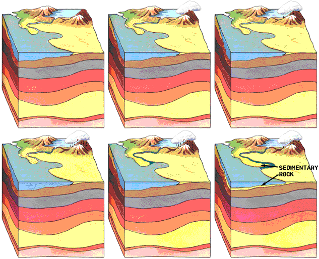
And, the main type of rocks they study are called sedimentary rocks.
Most sedimentary rocks are formed in lakes, rivers, or oceans.
 Rains
Rains
fall in higher elevations, forming streams, then rivers. Rivers and
streams carve out tiny bits of solid rock from the landscape and carry
them downstream. If the rock bits are fairly coarse (about the size of
salt grains, or larger), they are called sand. If they are a little finer, they are called silt. If the rock bits are really fine (like flour) they may be called mud, or clay. Remember, sand, silt, and mud/clay refer to the size of the grains, not what they are made of.
At some point in their travel, the rivers slow down. This may be
because the surrounding land is very flat, or the river may enter a
lake, or the ocean. When the water slows down, the grains of sand,
silt, or mud being carried by the river drop to the bottom and form layers of sediment. Usually a layer will be mostly sand, mostly silt, or mostly mud, but they are often mixed up.
If you have been to a beach, you stood on a pile of sand that was eroded by the forces of rain and  wind
wind
from rocks many hundreds of miles away, was transported by a stream or
river for a long distance, was broken into tinier and tinier bits as it
traveled, and was then spread out in a long, continuous bar by the work
of waves, tides, and wind.
A beach is just one type of many sand deposits that may become deeply buried and later become a huge oil or gas field!

Here’s a slightly more complicated example. Take a look at the satellite photo of the Mississippi River’s delta. Delta is a fancy word for a big pile of sand that forms in an ocean or lake at the end of a stream or river.
In this case, the Mississippi River is bringing down a huge amount of
sediment that has been scoured from all over eastern North America, and
is forming new land (many miles long) right before our eyes, south of
the city of New Orleans, Louisiana.
Note the main channel of the Mississippi River snaking down through
the delta. The darker areas on the picture show where land sticks up
(just barely, no more than a foot or two) above the surface of the ocean
and allows plant life to grow. The lighter, whitish areas show
sediments (sand, silt, and shale) that are just under the surface of the
water. The darker blue to the left shows deeper water.
The portion of the delta visible in the photograph is about 46 miles
long and 21 miles wide (74 X 33 km)! Imagine if that gigantic pile of
sand and silt was buried thousands of feet deep. We would have the
potential for an absolutely tremendous oil or gas field!
An Ancient Delta – Now a Gas Field!
This is where the study of geology starts to get very cool. It
happens when we take modern-day examples like the Mississippi Delta
(above), and find ancient systems that are very much the same.

During Red Fork time (about 300 million years ago), most of Roger Mills County, Oklahoma was under water.
Sediments from a river to the east poured into the ocean near the green
arrow. The sand from the river spread out on the sea floor and formed a
huge stratigraphic trap called the Red Fork delta. The Red Fork Delta
is represented by the greenish area.
The brown triangles indicate oil and gas (mainly gas) wells that produce from the Red Fork formation.
Each of the blue squares is one
section of land, or one square mile. So, the Red Fork Delta is about 24
miles long in the north-south direction and about 22 miles wide in the
east-west direction. Not only is it big, the sediments of the Red Fork
Delta are now buried very deep…over two miles deep!
Look on the Scout Ticket page to see the scout ticket from the Carrel #1-11, a well completed in the Red Fork formation in this very field!


Comments are closed.