Tag Archive for: Mafuta na Gesi

Tanzania Seafarers To Start Exploration of Oil and Gas in Deep and Shallow water

THE Tanzania Seafarers Community (TSC), has declared its readiness to start performing a wide range of tasks associated with exploring oil and gas, both in deep and shallow waters.

THE Tanzania Seafarers Community (TSC), has declared its readiness to start performing a wide range of tasks associated with exploring oil and gas, both in deep and shallow waters.

The move comes after the accomplishment of all legal procedures and fulfillment of sailor’s demands such as health insurance and working contracts to companies that they will be working with.

Speaking in Dar es Salaam, the TSC Chairman, Mr Frank Chuma said that they have reached agreement with the government on the fulfillment of important requirements that are needed by seafarers.

He said next process shall be signing contracts between the Community and Tanzania Petroleum and Gas Development Corporation (TPDC). “We are happy that everything went smoothly in accordance to expectations although it took three years until the accomplishment. We are now ready to work anywhere within and outside the country,” he said.

Also Read:     interesting-business-opportunities-in-tanzania-oil-and-natural-gas-sectors-for-local-entrepreneurs

“The TSC concern was to see local sailors benefit from opportunities that shall be found in their homeland,” he added. He said the move shall reduce unemployment rate for local seafarers who are about 5,000 country wide, as they are now going to be attached to both foreign and local companies that are associated to the oil and gas exploration sector.

“In accordance with Tanzania shipping business laws, for a sailor to go to the sea he/she must have insurance. We therefore recommend the remarkable contribution by the finance ministry,” he said.

He added that the issue of employment is a major problem for sailors something which pushed them to have number of consultation meeting with different stakeholders including China embassy, Tanzania Ports Authority (TPA), TPDC and the Ministry of finance.

He said, the Chinese Embassy has agreed to cooperate with them in fishery, oil and gas as well as other related activities and they are ready to bring their gears to help revive the activities in the country.

For his part, the renowned maritime instructor Mr Charles Chagula, urged the sailors to work hard once being attached to the companies as a way to prove their capacity and morality.

“We have reached the ultimatum of what we have been fighting for the past three years, it is our turn now to work hard and ensure effective delivery of our profession to the public,” he said.

See Why in Tanzania there is the biggest increases in Demand for Natural gas


The
aboundance of natural gas reserves in Tanzania  attracts many investors , contractors,
equipment suppliers  and consultant firms
to offer business opportunities  in
Tanzania.  This  implies that, natural gas will continue  to play an increasingly important role in
meeting demand for energy in Tanzania.
       There are many reasons for the long term
expected  increase in demand for natural
gas in Tanzania, which include the following.
1.Increase
 in the number of  New homes
New
homes increase day after day, family size increase as well, as these new homes built,
the consumption of natural gas mounts, and the number of families use natural
gas to cook and heat them also increase.Therefore increase of new homes using
natural gas is expected drive demand for Natural gas in Tanzania.
2.Expansion
of gas based power generation
The
largest addition to gas demand in Tanzania where the most of expansion of power
are taking place.  forexample the
construction of kinyerezi 1 gas fired power plants, they will be supplied gas
from Mtwara through Mtwara-Dar es Salaam pipeline, So more gas will be needed
to meet the demand as the result of natural gas demand increases.
3. Technological
Advancements
 – Currently, the majority of energy used by the commercial
sector is in the form of electricity. Similarly, many common household
appliances can only run on electricity. The advancement of natural gas
technology in the form of offering natural gas powered applications that may
compete with these electric operated appliances may provide a huge increase in
demand for natural gas. Natural gas cooling, combined heat and power, and
distributed generation are expected to make inroads into those applications that
have traditionally been served solely by electricity.

Transportation
Natural
gas use in transportation are almost negligible.Although natural gas powered
vehicles are very useful for reducing environment pollution compered to fuel
powered vehicles. The demand for alternative vehicles fuel vehicles (Including
natural gas vehicles) will increase demand in natural gas. Although to
accomplish this, technology is required.

MY
FINAL WORDS
This
general increasing of natural gas demand in Tanzania can be expected to the
general growth of economy of Tanzania and improving living standard of
residents.
Dear
readers we would love to hear your views on all of these

See Where does Petroleum Come from

We are going to talk Origin of petroleum
But First  I will talk
about the origin of the world itself, Rock outcrop at the surface of the earth
have been producing oil for century and this oil was known as rock oil, Because
at that period oil was seeping out the rock, But at the middle of 19 century
some body called the word Petroleum, Petro is greak word meaning rock and leum
is latin word meaning oil and they combine these two word called petroleum.
Then become popular word and eventually the word adopted by industry itself and
now is known as petroleum industry
 Where does petroleum come from?
 There are two theory about where petroleum come from
·        
Organic
theory :
State that oil was developed over millions of years from organic
materials from remains of animals and plants that were once alive, the proteins
life floaded in the sea like plankton and algae then die and fed to the bottom
of the ocean.
·        
Inorganic theory In this teory the source of oil
is from chemical reactions between minerals, In the laboratory scientists have
been able to make methane gas by applying heat under high pressure to minerals
even though a very small percentage of oil today may have developed from in
organic chemical reactions between minerals the source of most our oil appear
to be the result of organic decomposition.
These decomposition is the decay of the
remains of animals and plants that died millions of years ago
                When
am talking about animals that was died and generate oil am talking about tiny
microscopic animals that live in the sea eg plankton and algae
    These animals die
under special circumstances, and what do I mean by that?
         As you know
when most animals die other animals and bacteria arrive to consumes the remains
living nothing. In the shallow water where these animal live, sweep current
come on and push these down to where there is no enough oxygen to live and so
they die. These animals went from an aerobic environment where there is plenty
of oxygen to an anaerobic environment where there is little oxygen where all
die at the same time.
In an anaerobic there also not enough oxgen for most animals
microbs or bacteria to come along and eat the remains of planktons and algae so
the just lie there until the get buried by particles of silt and sand.
Over period of millions of years these layers of remains in
sand and silt particles are buried and curved by more layer until first layer
become very deep. All the way of these layer to press down and squeezed caused
increased in pressure and temperature until the sedimentary layers are formed
into shale, sediment change into rock, and little dead microbs get cooked into
hydrocarbon.
These is the theory of how petroleum and coal is made.
Oil is made from animal like plankton
Coal is made from vegetation like plants

Gas is made from deeper formation where microbes are cooked
longer

The Ministry of Energy & Mineral Development has announced that
the “Uganda International Oil & Gas Summit” (UIOGS) will be held in
Kampala on 16-17 September 2015.

With a first-class conference programme led by Government, Public
Sector and Private Sector industry leaders; the Summit marks an
important point on the global calendar.

UIOGS is held under the Patronage of Eng. Irene Muloni,Minister of
Energy and Mineral Development; and will be used by the Ministry as its
official platform for meeting international companies and presentation
of the multitude of energy projects presently ongoing or planned for in
Uganda.

Uganda has much to offer the global oil and gas community and 2015 is
an exciting year as the country moves towards commercial production.
Uganda is blessed with its natural resources and now has an estimated
6.5 billion barrels of oil in place, a high drilling success rate of
85%, advanced refinery plans, vast acreage of underexplored areas rich
in hydrocarbons and much to look forward to with the new licensing
rounds.

The UOGS programme will provide an invaluable insight into all the major issues, challenges and opportunities including:

  • Focus on the licensing rounds and new opportunities
  • Update on existing fields and exploration success
  • Financial and regulatory frameworks
  • Uganda’s Refinery Project – 60,000 bpd by 2020
  • Move to commercial production
  • Supporting the oil and gas industry through a skilled workforce and local content
  • Infrastructure developments to support oil & gas
  • How can a successful oil industry support our drive towards rural electrification

The Ministry of Energy & Mineral Development will be using the
UIOGS platform to actively engage with allits partners and suppliers
from around the world. The services of the renowned market leaders for
oil & gas conferences; Global Event Partners have been engaged to
work alongside domestic experts Image Care to ensure that UIOGS is a
first-class event that puts Uganda firmly on the global map.

UIOGS is a two day conference that will be held at the Kampala Serena
Hotel on 16-17 September 2015. The programme will be opened by Hon. Eng
Irene Muloni and will feature more than 30 Government officials,
Company leaders and Industry experts gathered from Uganda, the region
and throughout the world to give Uganda a truly global platform.

HIVYO NDIVYO MAFUTA NA GESI YANAVYOTENGENEZWA (ORIGIN OF PERTOLEUM)

Karibu msomaji wa Petroleum field ambapo  today I am going to share with you Asili ya mafuta na Gesi (origin of Petroleu).

Where does Petroleum Come from? (Nini asili ya Mafuta na gesi)

Well,  Kabla hatujaua jinsi mafuta na gesi yanavyotengenezwa lets  discribe the word Petroleum its self.

Karne kadhaa zilizopita Rock outcrop kwenye  uso wa Dunia ilikuwa ikizalisha mafuta.na hayo mafuta yaliitwa Oil Rock because oil was seep out the rock itself

 Kati kati mwa Karne ya 19 watafiti walikuja na idea mpya mbapo walisema, Neno Petroleum Linatokana  na maneno mawili neno la kigiriki Petro ambalo mana yake kwa kingereza ni Rock, na Neno Leum  ambalo ni neno la kilatin ambalo maana yake kwa kingereza ni Oil

Summary.

Petro means Rock

Leum means Oil.

Now, Mafuta na gesu yanatengenezwaje? Lets go

Kuna theory kuu 2 zinazozungumzia origin of Petroleum (asili ya Mafuta na gesi).Nazo  ni hizi zifuatazo.

1.Organic theory
2.Inorganic theory


Lest first descuss about Organic Theory.

Theory hii inaeleza kuwa Petroleum (mafuta na gesi) ilitokana na mabaki ya mimea na wanyama walikoufa miaka million kadhaa iliyopita.

Baadhi ya Wadudu wadogo (microscopic animals) ambao wanaishi baharin(ocean) Kama Planton na Algae hufa na n kujifukia chini ya bahari kwa kingereza wanasema(they burried into bottom of the ocean). Mabaki yao ndio huwa chanzo cha mafuta na gesi.

SPECIAL CASE
Kama unavyojua mnyama yoyote akifa wanyama wengine na bakteria huja na kula yale mabaki. (when animal died, other Animals and bacteria comes to consume remains).

Kwa hiyo kwenye maji ya kina kifupi (Shallow water)ambapo  wadudu hawa huishi,mkondo wa maji huja na kuwasukuma chini ya maji ambapo hakuna hewa safi(oxygen) ya kutosha na hivyo kupelekea wao kufa.

Wanyama hao husukumwa na mkondo wa maji kutoka kwenye mazingira yenye oxygen ya kutosha (Aerobic environment) na kuwapeleka kwenye mazingira ambayo yaNA ufinyu wa hewa safi ya Oxygen(Anaerobic enviroment) hivyo hufa mara moja.

Kumbuka kwenye anaerobic environment (mazingira yenye hewa finyu ya oxgen) hakuna wanyama wala bakteria wengine wanaoweza kuja kula mabaki ya viumbe hivyo vilivyokufa.

So, Mabaki ya wanyama hao yatabaki hapo mpaka yatakapouja kufunikwa na mchanga na udongo (get burried by Particles of sand and silt)

Cycle hii itajurudia mara kwa mara.Baada ya mika kadhaa this particle of sand and silt ambazo zilifunika wanyama hao waliokufa zinakuwa zinapata mkandamizo wa  layer nyingi zaidi hadi ile layer ya kwanza inakuwa imezama chini kwenye kina kirefu.

Hii inasababisha kuongezeka kwa Presha na heat mpaka sediment zina badilika kwenda kwenye sedimentary rock,na zile remains hubadilika kuwa hydrocarbon.

Note
Kwa theory hii ya mafuta na gesi yanavyotengenezwa hata makaa ya mawe (coal) pia hutengenezwa kwa mtindo huu. Isipokuwa,

Mafuta (Oil) hutengenezwa kutokana na mabaki ya wanyama kama Plankton.

Makaa ya mawe (Coal) Hutengenezwa kutokana na mabaki y mimea mbali mbali.

Gesi hutengenezwa baada ya mabaki ya wanyama kufukiwa kwa muda wa mrefu zaidi.

Pia kumbuka napozungumzia wanyama wanaotengeneza mafuta na gesi hapa sizungumzii kila mnyama  hapa nazungumzia wanyama wadogo (microscopic animals) like Plankton and algae.

Now lets move on second theory.

 2. Inorganic theory


Kwenye theory hii mafuta hutengenezwa kwa kufanya reaction between Minerals.

Wanasayansi wamejaribu kutengeneza gesi ya methane kwa  kwa kuapply heat na pressure into minerals.

Lakini hata hivyo ni ni kiwango kidogo sana cha mafuta siku hizi kinachotengenezwa kwa njia hii.

FINAL WORDS

Najua kuna mengi sana kuhusiana na origin of Petroleum ambayo sijayazungumzia hapo,kama unachochote cha kuongezea kuhusiana na Origin ya Petroleum,please share with us

GESI ASILIA KUOKOA BILIONI 200 KWA MWAKA

Imeelezwa kuwa Taifa litaokoa takribani Shilingi Bilioni 202 za
Kitanzania kwa mwaka endapo mradi wa usambazaji wa gesi asilia katika
jiji la Dar es Salaam utatekelezwa.

Hayo yalibainishwa hivi karibuni mjini Dodoma katika Mkutano wa
Maaskofu wa Makanisa ya Kipentekoste (CCT), wakati Waziri wa Nishati na
Madini, Profesa Sospeter Muhongo akiwasilisha mada iliyohusu rasilimali
za mafuta na gesi kwa manufaa ya Watanzania wote.

Akielezea mradi husika, Waziri Muhongo alisema lengo kuu ni kuweka
mtandao wa mabomba ya kusambaza gesi na vituo vya kujazia gesi magari
ambapo ulifanyiwa upembuzi yakinifu mwaka 2006/2007 na kuhusisha magari
8,000 na makazi yapatayo 30,000.

Profesa Muhongo alisema ujenzi wa mradi huo unatarajiwa kuanza Julai
2015 ambapo kwa sasa zoezi la kumtafuta Mkandarasi pamoja na fedha za
ujenzi takribani Dola za Marekani milioni 76 linaendelea.


Askofu
Dkt. Valentino Mokiwa wa Kanisa Anglikana Dayosisi ya Dar es Salaam
akitoa neno la shukrani kwa Waziri wa Nishati na Madini Profesa Sospeter
Muhongo (hayupo pichani) baada ya Waziri huyo kuwasilisha mada katika
Mkutano wa Maaskofu wa Makanisa ya Kipentekoste nchini (CCT).

Aidha, Waziri Muhongo alizungumzia faida iliyopatikana kitaifa kwa
kutumia gesi asilia kwa kipindi cha miaka 10 kutoka mwaka 2004 na
kubainisha kuwa Taifa limepata mapato kiasi cha Dola za Marekani 235.9
milioni.

Pia, alisema Taifa limeokoa kiasi cha Dola za Marekani 5.3 bilioni
katika kuzalisha umeme na kiasi cha Dola za Marekani 449.7 milioni
katika viwanda.

Manufaa mengine ni pamoja na Halmashauri husika hupata Kodi ya Huduma
(service levy) ambayo ni asilimia 0.3 ya mapato ya mauzo ya gesi.
Waziri Muhongo alitoa mfano wa mradi wa SongoSongo, ambapo Halmashauri
ya Kilwa hupata takribani shilingi za Tanzania milioni 100 kila baada ya
miezi mitatu.

Akizungumzia faida za bomba kuu la kusafisha na kusafirishia gesi
asilia ambalo ujenzi wake unaendelea, alisema mitambo iliyopo sasa,
imesababisha nchi kupoteza shilingi za Tanzania trilioni 1.6 kwa mwaka
kwa kutumia mafuta kuzalisha umeme badala ya gesi asilia.

Alisema endapo bomba hili litatumika katika kiwango chake cha juu
(784 mmscfd), gesi itakayosafirishwa kwa kipindi cha miaka 20 ni
asilimia 12 tu ya gesi iliyogunduliwa hadi sasa.

“Nchi itaokoa Dola za Marekani bilioni moja (sawa na shilingi za
Tanzania trilioni 1.6) kwa mwaka kutokana na mitambo iliyopo nchini
inayozalisha umeme kwa kutumia mafuta kuanza kutumia gesi asilia,”
alisema Waziri Muhongo.

Aidha, aliongeza kuwa bei ya uzalishaji umeme itapungua kwa uniti
moja (KWh) ambapo alifafanua kuwa umeme unaofuliwa kwa dizeli na mafuta
ya aina nyingine hugharimu senti za Marekani 30 hadi 45 wakati bei ya
kuzalisha uniti moja hiyo hiyo ni senti za Marekani saba kwa umeme
utokanao na gesi asilia.

Alizitaja faida nyingine za mradi mpya wa bomba la gesi kuwa ni
pamoja na ajira katika mitambo itakayojengwa Madimba na SongoSongo kwani
kila mtambo utahitaji kiasi cha wafanyakazi 60. Vilevile, alisema mradi
utatoa ajira katika sekta za afya, elimu, maji usafiri pamoja na huduma
nyingine za kijamii zitakazohitajika.
SOURCE;WWW.MEM.GO.TZ

AINA ZA TRAP ZA MAFUTA NA GESI (OIL AND GAS TRAPS)

Oil and Gas Traps

All oil and gas deposits are found in structural or stratigraphic traps.  You
may have heard that oil is found underground in “pools,” “lakes,” or
“rivers.”  Maybe someone told you there was a “sea” or “ocean” of oil
underground.  This is all completely wrong, so don’t believe everything
you hear.

Oil Moving Through Pore Space In Sandstone

Oil Moving Through Pore Space In Sandstone

Most oil and gas deposits are found in sandstones and coarse-grained
limestones.  A piece of sandstone or limestone is very much like a hard
sponge, full of holes, but not compressible.  These holes, or pores, can
contain water or oil or gas, and the rock will be saturated with one of
the three.  The holes are much tinier than sponge holes, but they are
still holes, and they are called porosity.

The oil and gas become trapped in these holes, stays there, for
millions of years, until petroleum geologists come to find it and
extract it.

When you hold a piece of sandstone containing oil in your hand, the
rock may look and smell oily, but the oil usually won’t run out, and you
can’t squeeze sandstone like a sponge!   The oil is trapped inside the
rock’s porosity.

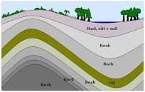
Oil Formation and Oil Movement

The very fine-grained shale we talked about previously is one of the
most common sedimentary rocks on earth.  In many places, thousands upon
thousands of feet of shale are stacked up like the pages in a book, deep
underground.  It is not unusual to have layers in the earth’s crust
made up mostly of shale that are 4 miles thick.  These shales were
deposited in quiet ocean waters over millions of years time.

During much of the earth’s history, the land areas we now know as
continents were covered with water.  This situation allowed tremendous
piles of sediment to cover huge areas.  The oceans may have left the
land we now live on, but the great deposits of shale and sandstone
remain deep underground….right under our feet!

The Tiny Gigantic Kingdom

In the deep ocean, far from land, about the only sediment deposited is the fine-grained clastic rock known as shale.But
what about the oil and gas?  For the answer, we need to move to the
ancient oceans that once covered almost all of the earth.

Tiny Microfossils Make Up the Sea-Floor Ooze

Tiny Microfossils Make Up the Sea-Floor Ooze

A lot of other material is deposited along with the clay or mud-sized
sediments.  We often think of sharks and whales as being the kings of
the deep oceans.  Actually, there are other animals that have
established giant kingdoms in the sea…the largest and most impressive
kingdoms of all!  These animals are the various kinds of microscopic
creatures….both plant and animal.  Most of them would fit on the head of
a pin. They are tiny, but there are uncountable trillions of them.  
When these creatures die, they sink to the bottom and become part of
the  sediments there that will eventually turn into shale.

The animals die by the trillions and rain down on the ocean floor all
the time.  And since the beginning of life on earth, they have been
living their exciting lives in the ocean, dying, sinking to the bottom,
and becoming part of the once-living matter that is part of most shale
rocks.

It is the trillions of tiny animals that make up most of the gunk
(the scientific name for this gunk is “ooze”) deposited on the ocean
floor.  It’s a very fine-grained goop containing a lot of organic
material mixed with the clay-sized particles that form shale.  It is
called organic-rich shale.

Later, when thousands of feet of organic-rich shales have piled up
over millions of years, and the dead animal bodies are buried very deep
(more than two miles down), an amazing thing happens.   The heat from
deep inside the earth “cooks” the animals, turning their bodies into
what we call hydrocarbons……oil and natural gas.

At first, the oil and gas only exist between the shale particles as
extremely tiny blobs, left over from the decay of the tiny animals.  
Then, the Crude Oil Samplesintense
pressure of the earth squeezes the oil and gas out of the shale, and
the oil and gas fluids gather together in a porous layer and move
sideways many miles.  On their way, they may meet up with other
traveling oil or gas fluids.

Finally, the oil and gas may become “trapped” in a rock formation
like sandstone or limestone….a hydrocarbon trap. The oil and gas stay
there, under tremendous pressure, until the petroleum geologist comes
looking for it.  Without a trap, the geologist has no place to drill.  All oil and gas deposits are held in some sort of trap.


The Two Types of Traps

Structural Traps

These traps hold oil and gas because the earth has been bent and
deformed in some way.  The trap may be a simple dome (or big bump), just
a “crease” in the rocks, or it may be a more complex fault Structural Traptrap
like the one shown at the right.  All pore spaces in the rocks are
filled with fluid, either water, gas, or oil.  Gas, being the lightest,
moves to the top.  Oil locates right beneath the gas, and water stays
lower.

Once the oil and gas reach an impenetrable layer, a layer that is
very dense or non-permeable, the movement stops.  The impenetrable layer
is called a “cap rock.”

Stratigraphic Traps

Stratigraphic traps are depositional in nature.  This means they are
formed in place, often by a body of porous sandstone or limestone
becoming enclosed in shale.  The shale keeps the oil and gas from Stratigraphic Trapescaping
the trap, as it is generally very difficult for fluids (either oil or
gas) to migrate through shales.  In essence, this kind of stratigraphic
trap is surrounded by “cap rock.”


Here are four traps.  The anticline is a structural type of trap, as is the fault trap and the salt dome trap.

Four Types Of Structural and Stratigraphic Traps


The stratigraphic trap shown at the lower left
is a cool one.  It was formed when rock layers at the bottom were
tilted, then eroded flat.  Then more layers were formed horizontally on
top of the tilted ones.  The oil moved up through the tilted porous rock
and was trapped underneath the horizontal, nonporous (cap) rocks.

Another Stratigraphic Trap

This hole  has been drilled into a sandstone that was deposited in a
stream bed.  This type of sandstone follows a winding path, and can be
very hard to hit with a drill bit!  The plus is that old Well Drilled Into Ancient Stream Stratigraphic Trapstream beds make excellent traps and reservoir rock, and some of these fields are tens of miles long!

This type of sandstone is usually enclosed in shale, making this a stratigraphic trap.

Just because you drill for oil or gas does not mean that you will
find it!  Oil and gas reservoirs all have edges.  If you drill past the
edge, you will miss it !  This might explain why your neighbor has a
well on his land, and you do not!

Stratigraphic Problems When Drilling

When you drill, you may find a producing reservoir very near the surface. But many other things can happen:

You might drill into a reservoir that has been depleted (all the oil
and gas removed) by another well.  There may be a new infill reservoir
between two wells that could be developed with a third well.  Or Non-Continuous Reservoirsone
that was incompletely drained.  Maybe if you drill a little deeper you
might hit a deeper pool reservoir!  You might be able to back up and
produce a bypassed compartment.  The petroleum geologist has to think of
all these things when planning a new well!

Structural Problems When Drilling

Finally, structures in the earth can give the PG many challenges.  
Look at this diagram.  Imagine you first drilled the hole on the left
into the green layer which represents a nice oil and Faulting Causes PROBLEMSgas-bearing rock.  YES!  You have a great well, producing lots of oil and gas!

Then you drilled your second hole to the east (right) of the first one.  What happened to that hole? (answer below)

Answer:  The oil reservoir has been split in two by the fault,
which is nothing but a place in the earth where rock layers break in
two.   The arrows on the diagram show that the rocks moved DOWN on the
LEFT side of the fault and UP on the RIGHT side of the fault.   This
created a GAP in the oil field……right where you drilled your second
hole!  Incredibly bad luck!  Or, bad seismic!  Your second hole is a DRY HOLE.


Some diagrams from “A Primer of Oil and Gas Production” and “Pennsylvanian Sandstones of the Mid-Continent”

HIVI NDIVYO VITU 5 AMBAVYO PETROLEUM GEOLOGIST HUVIFANYA


Net Pay Map

Prospecting is the work the petroleum geologist does to locate a place to drill a test hole, which hopefully can be turned into a producing oil or gas well!

Most petroleum geologists work in an office, where they have access to a lot of data.
This includes electric logs, core records, drilling records, scout
tickets, and production data. They use the data to construct maps,
cross-sections, and databases.  These tools help them locate the best
places to drill their test holes.

The geologist studies his maps and cross-sections and runs computer
simulations that help him select the next best location to drill. He is
always thinking about the next drilling location…or prospect!

He will want to know what type of trap he is dealing with, and the
composition of the sedimentary rocks he will be drilling through. He
needs to estimate the porosity of his prospective “pay zone.” He wants
to know if dangerous high pressures can be expected in the new hole. If
seismic data is involved in the prospect, he will consult with the
geophysicist and get his opinion of the prospect.

The geologist is always interested in anything that happens in her
area, particularly news of new discoveries by other companies!  If she
sees a promising new area, she will recommend to the land department
that an attempt be made to lease the land; the leased acreage will then
be available for drilling later.

When the geologist has finally found the correct spot, she spends much
time cross-checking to ensure she has not missed anything. She wants to
make sure she is not “surprised” by any of the following:

  • Discovering the selected location was already drilled by another company 40 years ago (and was dry)
  • Discovering that her company has no legal right to drill on the location (lease problems)
  • Unexpected faults or other geologic problems that crop up during drilling and ruin the prospect
  • Discovering that the hole is being drilled in the wrong place after
    drilling begins (a very bad thing that has actually happened!)

Step 2 – The Petroleum Geologist Packages The Deal

Packaging

Once the new location is defined, and the geologist is satisfied the
prospect is a good one, the work is just beginning. He has a large
amount of rough data available in the form of work maps, that he used to
satisfy himself of the feasibility.  Now, he must condense this large
data mass into a set of presentation materials that can be shown to
non-geologists.

To package the deal, he will prepare sets of simplified maps and
cross-sections, highly-colored and attractive to the eye. He may use Powerpoint,
or other presentation software. Creativity, design sense, and art
skills are important during this phase. He needs to anticipate all
possible questions, and be prepared to answer each one of them. He must
be very sure of himself and his facts before he moves to the next step.

Step 3 – The Petroleum Geologist Sells the Deal

5 steps - sell the deal

Now the geologist must step into a role that is often uncomfortable
for him … selling his prospect. It may be uncomfortable because
geologists are scientists, with scientific backgrounds and schooling.
They are used to talking to other scientists. But now the geologist must
become a salesman in order to convince people who are not geology
experts of the value of the prospect.  These people may include
managers, bankers, engineers, and oil and gas investors.

Of course, the geologist wants to see her prospect drilled.  But she
will take great pains to ensure all her data is presented accurately and
concisely.  She is bound by her own integrity, the integrity of any
professional group she is a member of, and the integrity of her
profession.


She is looking to convince her clients that

  • the prospect is worth drilling,
  • investors will get a fair return for their money
  • the provided financing will be money spent wisely

Even an inexpensive test hole can cost a couple of million dollars,
and some exploration tests may run into many tens of millions! So the
geologist wants to be very sure of her facts.  All her clients must
believe the proposed well has a reasonable chance of being successful.

The geologist will meet with the landman (females in the business are
also called “landmen”), who will ensure the company has the legal right
to drill in the chosen spot. He will consult with the engineer, who
will determine the exact cost of drilling and completing the hole. 
Marketing personnel will ensure the company has a market (buyer) for the
oil, or a pipeline for the gas. Managers, responsible for ensuring the
company’s drilling budget is spent wisely, will also approve the test.
If outside financing will be used, the geologist will explain the
prospect to representatives of the bank or other individuals or
partnerships that put up the money.

When he’s done, the geologist will have “sold” his prospect to anywhere from a few to several dozen people.

Step 4 – The Petroleum Geologist Monitors the Drilling of the Test

5 steps - drilling rig

Next comes the part that every geologist enjoys the most! Drilling
the hole! It has now been several months since the geologist started
working on his prospect. Now the surface owners have been paid, permits
acquired, and money raised.  Roads and the drilling location have been
built, pipe and supplies have been ordered.  Also, the energy company
has engaged a drilling contractor who owns and operates the drilling
rig.

The drilling contractor will drill the hole in the manner specified
by the company. The contractor will have leeway to select the type of
drill bits to be used, hire a drilling crew, and make many other
decisions concerning the actual drilling.  Virtually all holes are
drilled by contractors.

Drilling a hole is a very complex procedure involving many people and
many critical steps. Nearly everything must go right. Dangerous
machinery, bad weather, and continuous mechanical failures are faced
daily. The work goes on for weeks to months, 24 hours a day, nonstop. A
slip-up at any point can ruin the very expensive hole, cost a fortune,
or get people killed.

The geologist will closely monitor all aspects of the drilling as it
takes place. She will select an electric-logging company, and the proper
wireline logging tools to evaluate the hole. She will usually hire a
mud logging contractor to “sit” the well day and night.  The mud logger
will study the well cuttings, report shows of oil and gas, and keep
track of other things on the location. The geologist will monitor the
formation tops as they are encountered, and discuss the progress of the
drilling with the investors. The geologist will decide where and when to
take cores or drill-stem tests. Finally, after the hole is logged with
electric logs, she will examine the logs and recommend the hole be completed or plugged.

Step 5 – The Petroleum Geologist Works With The Engineer to Complete the Well

5 steps - completion

At last the hole is drilled!  At this time, a decision must quickly be made to attempt a completion and make the hole a well,
or plug the dry hole.  Completion costs are extremely high, so it must
be believed the expensive completion will be worth the money. No one
wants to throw good money after bad. Justifying a completion can be a
grueling process. It almost always takes place in the middle of the
night!

The job of completing the hole is mainly in the hands of the
petroleum engineer. The engineer will decide the type of casing to use,
and the method of cementing, He will design the completion procedure
(which may involve perforating, breakdowns, acid jobs, fracks, and
pumps). However, he will depend on the geologist to advise him on
various topics. To start, the geologist will give the engineer a list of
formation tops, and tell the engineer exactly which zones should be
tested.

The geologist is often the person most familiar with the technical
practices of other oil companies in the area. No two companies are
exactly alike; some may come up with better ideas for certain
processes.  The geologist may be familiar with the most successful
fracturing or breakdown procedures of other companies. He might suggest a
certain style or method of perforation, or offer advice on cementing
techniques. He will relay this information to the petroleum engineer,
who will usually be thankful for the help! Working as a team, the
geologist and petroleum engineer will get the new well completed, and put it to work providing energy for all of us!

GEOLOGIST START WITH SEDIMENTARY ROCK


And, the main type of rocks they study are called sedimentary rocks. 
Most sedimentary rocks are formed in lakes, rivers, or oceans.
Sedimentary rocks - animated sequenceRains
fall in higher elevations, forming streams, then rivers.  Rivers and
streams carve out tiny bits of solid rock from the landscape and carry
them downstream.  If the rock bits are fairly coarse (about the size of
salt grains, or larger), they are called sand.  If they are a little finer, they are called silt.  If the rock bits are really fine (like flour) they may be called mud, or clay.  Remember, sand, silt, and mud/clay refer to the size of the grains, not what they are made of.
At some point in their travel, the rivers slow down.  This may be
because the surrounding land is very flat, or the river may enter a
lake, or the ocean.  When the water slows down,  the grains of sand,
silt, or mud being carried by the river drop to the bottom and form layers of sediment.  Usually a layer will be mostly sand, mostly silt, or mostly mud, but they are often mixed up.
If you have been to a beach, you stood on a pile of sand that was eroded by the forces of rain and A Future Oil and Gas Reservoirwind
from rocks many hundreds of miles away, was transported by a stream or
river for a long distance, was broken into tinier and tinier bits as it
traveled,  and was then spread out in a long, continuous bar by the work
of waves, tides, and wind.
A beach is just one type of many sand deposits that may become deeply buried and later become a huge oil or gas field!

Satellite Photo - Mississippi River Delta

Satellite Photo – Mississippi River Delta

Here’s a slightly more complicated example. Take a look at the satellite photo of the Mississippi River’s delta.  Delta is a fancy word for a big pile of sand that forms in an ocean or lake at the end of a stream or river.
In this case, the Mississippi River is bringing down a huge amount of
sediment that has been scoured from all over eastern North America, and
is forming new land (many miles long) right before our eyes, south of
the city of New Orleans, Louisiana.
Note the main channel of the Mississippi River snaking down through
the delta.  The darker areas on the picture show where land sticks up
(just barely, no more than a foot or two) above the surface of the ocean
and allows plant life to grow.  The lighter, whitish areas show
sediments (sand, silt, and shale) that are just under the surface of the
water.  The darker blue to the left shows deeper water.
The portion of the delta visible in the photograph is about 46 miles
long and 21 miles wide (74 X 33 km)!  Imagine if that gigantic pile of
sand and silt was buried thousands of feet deep.  We would have the
potential for an absolutely tremendous oil or gas field!

An Ancient Delta – Now a Gas Field!

This is where the study of geology starts to get very cool.  It
happens when we take modern-day examples like the Mississippi Delta
(above), and find ancient systems that are very much the same.

Ancient Red Fork Delta in Roger Mills County, Oklahoma - Now a Gas Field!

Ancient Red Fork Delta in Roger Mills County, Oklahoma – Now a Gas Field!

During Red Fork time (about 300 million years ago), most of Roger Mills County, Oklahoma was under water
Sediments from a river to the east poured into the ocean near the green
arrow.  The sand from the river spread out on the sea floor and formed a
huge stratigraphic trap called the Red Fork delta.  The Red Fork Delta
is represented by the greenish area.    
The brown triangles indicate oil and gas (mainly gas) wells that produce from the Red Fork formation.
Each of the blue squares is one
section of land, or one square mile.  So, the Red Fork Delta is about 24
miles long in the north-south direction and about 22 miles wide in the
east-west direction.  Not only is it big, the sediments of the Red Fork
Delta are now buried very deep…over two miles deep!

Look on the Scout Ticket page to see the scout ticket from the Carrel #1-11, a well completed in the Red Fork formation in this very field!