
Roles of Petroleum Geoscientist In Petroleum companies

Few weeks ago i wrote an article about the roles of petroleum engineers in petroleum companies. To day we are going to see the roles of Petroleum geoscientist.
Let us begin
Petroleum Geoscientists are petroleum professionals who help petroleum companies identify the likely location of petroleum deposits. As geoscientist you study the earth and its many compounds, you learn about the earth composition, examine what is made up, the earth structure, looking at its layers and then divide them into their chemical and physical, the earth formation studying its geological features over time like ocean mountains, rivers and deserts and finally the earth physical phenomena, investigating physical properties of matter and energy of natural things that you can see test smell, hear and feel. In other words you study everything that is in, on and the surrounds the earth
Because earth is very big and there are many so things to study, geosciences has been divided into many specialize sciences like geology, geophysics, geochemistry
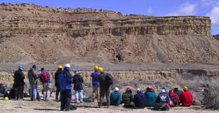
Petroleum geoscientist specialize in the study of location and characteristics of petroleum deposits very deep in the earth. To efficiently to explore for, petroleum geoscientists use many tools, they study the geology of the zones that identify potential petroleum reserves using geophysical techniques like geological survey, then to get data they use gravity meters and magnetic meters to identify type of the rock in the formation deep below the surface.
A gravity meters detects the change in the mass of the earth below, hard rock like igneous rock has large mass than soft rock like sedimentary rock. These measurement allow geologist construct basin and structure map.
you can also read:these are roles of petroleum engineers in petroleum companies
The magnetic meters measures the different amount of magnetism present in the rock type and is used to identify different type of rocks and structure.After analyzing their findings, geologists select good location for further analysis which will include seismic survey.
A seismic survey measure the reflection and refraction of sounds wave bouncing off the rock structures and types. As one of the powerful tool available to petroleum geoscientists, seismic survey are used to identify structures, fluid type and movement of fluids overtime.Seismic survey can be done on the land and on the ocean.
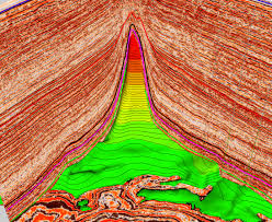
The data obtained from these best tools and sources along with sound information from seismic are compiled and send to the geoscientists like geophysicists, seismic interpreter and geo-modellers who used large computers to build geological model of the earth there deep under the ground.They use many resources to construct these geological models. With many advances in technology most of these models are currently build in a computer laboratory and utilize the largests advances in computer simulation. These simulation are updated and improved as more data is made available, as more data is acquired and processed.
Once geoscientist receive feedback from the computer, they study the data by analyzing and interprete the result, they finally ready to recommend next location of where to drill the first well. In Tanzania petroleum field there is area still need to be explored and produced. There is information need to be gathered on large scale and smll scale. We need more petroleum geoscientists in Tanzania petroleum field as we are in the exploration phase.
MY FINAL WORDS
So if you are looking for career or opportunity in petroleum industry, consider becoming petroleum geoscientist,because are key finder of petroleum


Comments are closed.